
Hurricane Ida has strengthened into a Category 4 as it heads toward landfall on the northern Gulf Coast today, where it will bring life-threatening storm surge, dangerous rainfall flooding and potentially catastrophic winds.
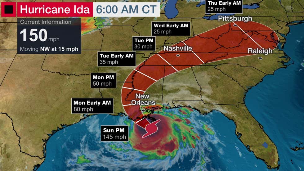
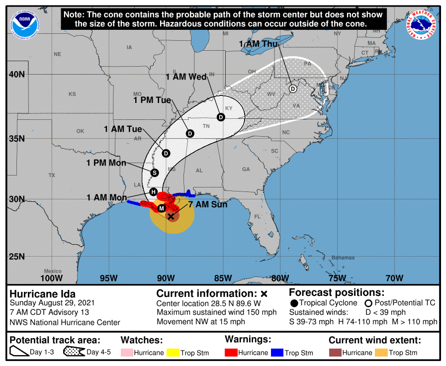
Ida had winds of 150 mph as of 6 a.m. CDT on Sunday, making it a strong Category 4 hurricane. Maximum sustained winds in Ida increased by 70 mph in 24 hours, which easily meets the criteria for the rapid intensification of a tropical cyclone.
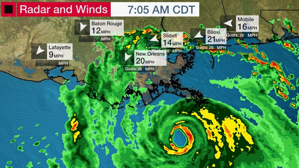
Bands of heavy rain containing gusty winds are beginning to spread into the northern Gulf Coast ahead of Ida’s landfall.
An elevated weather station in Southwest Pass, Louisiana, clocked a wind gust to 107 mph early Sunday. Storm surge has pushed water levels about 3 feet above normal at Shell Beach, Louisiana.
Ida is centered about 75 miles south of the southeastern tip of Louisiana and is moving to the northwest at 15 mph. Landfall in southeast Louisiana should occur this afternoon.
Weakening of Ida to a tropical storm and then a tropical depression is expected as it tracks inland through the lower Mississippi and Tennessee valleys early this week.
A hurricane warning is posted from Intracoastal City, Louisiana, eastward to the mouth of the Pearl River, including Lake Pontchartrain, Lake Maurepas, and the New Orleans metro area.
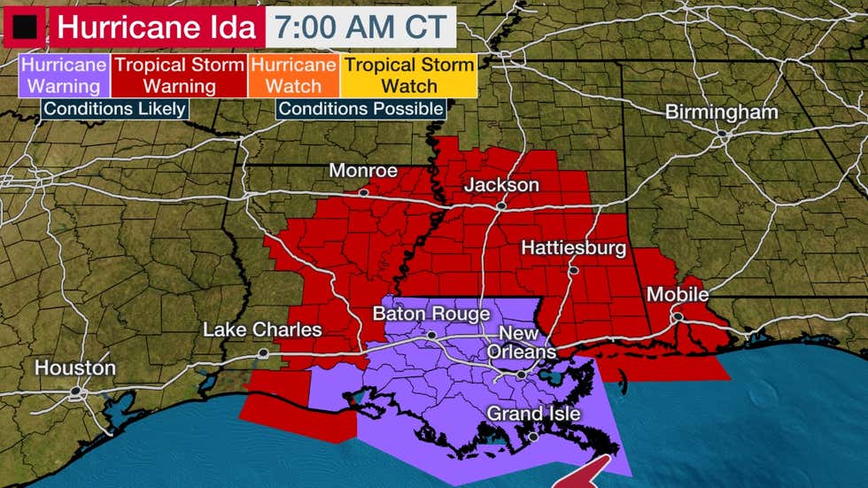
A tropical storm warning is posted from Cameron, Louisiana east to Intracoastal City, Louisiana, and from the Pearl River in Louisiana to the Alabama/Florida border. Tropical storm warnings are also in effect as far inland as northeast Louisiana and central Mississippi.
Forecast Impacts
Storm Surge
Life-threatening storm surge is forecast near and east of where Ida makes landfall. Follow all evacuation orders from local officials if you are in an area vulnerable to storm surge.
A storm surge warning has been issued from the Rockefeller Wildlife Refuge, Louisiana, to the Alabama/Florida border including Vermilion Bay, Lake Borgne, Lake Pontchartrain, Lake Maurepas and Mobile Bay. This means life-threatening inundation from storm surge is expected in these areas
The following storm surge inundations are possible if the peak surge happens at high tide, according to the National Hurricane Center (NHC). High tide is generally in the early morning hours of Sunday and Monday for many locations along the coasts of Louisiana and Mississippi.
-Port Fourchon, Louisiana, to the Mouth of the Mississippi River: 12 to 16 feet
-Morgan City, Louisiana, to Port Fourchon, Louisiana: 8 to 12 feet
-Mouth of the Mississippi River to Bay St. Louis, Mississippi, including Lake Borgne: 8 to 12 feet
-Burns Point, Louisiana, to Morgan City, Louisiana: 6 to 9 feet
-Bay St. Louis, Mississippi to Ocean Springs, Mississippi: 6 to 9 feet
-Lake Pontchartrain: 5 to 8 feet
-Ocean Springs, Mississippi, to the border between Mississippi and Alabama: 4 to 7 feet
-Intracoastal City, Louisiana, to Burns Point, Louisiana, including Vermilion Bay: 4 to 6 feet
-Lake Maurepas: 4 to 6 feet