
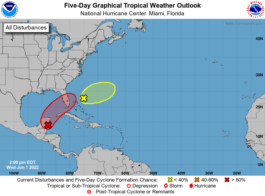
MIAMI — There is an 80 percent chance that a hurricane will form in the next 48 hours from an area of low pressure located near the east coast of the Yucatan Peninsula and the southeastern Gulf of Mexico, the National Hurricane Center (NHC) said today.
“This system is likely to become a tropical depression while it moves slowly northeastward over the northwestern Caribbean Sea and southeastern Gulf of Mexico during the next day or two,” the Florida-based forecaster said.
Although the NHC continues to monitor the area of disturbed weather near the Gulf of Mexico with a high chance of development, no impacts are expected for the U.S. Virgin Islands or Puerto Rico.
Near the Yucatan Peninsula and southeastern Gulf of Mexico: A large area of disturbed weather located near the Yucatan Peninsula is interacting with an upper-level trough over the Gulf of Mexico and producing a broad region of disorganized showers and thunderstorms.
Environmental conditions appear marginally conducive for gradual development, and this system is likely to become a tropical depression by the weekend as it moves northeastward into the northwestern Caribbean Sea, southeastern Gulf of Mexico, and crosses the Florida Peninsula.
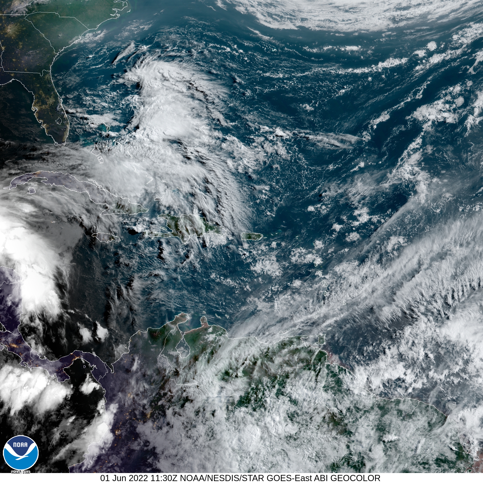
Regardless of development, locally heavy rainfall is likely across portions of southeastern Mexico, the Yucatan Peninsula, Guatemala, and Belize during the next couple of days, spreading across western Cuba, southern Florida, and the Florida Keys on Friday and Saturday. Interests in the Yucatan Peninsula, western Cuba, the Florida Keys, and the Florida Peninsula should monitor the progress of this system.
* Formation chance through 48 hours…medium…50 percent. * Formation chance through 5 days…high…70 percent. 2. Southwestern Atlantic northeast of the Bahamas: A weak surface trough located around 200 miles northeast of the central Bahamas is producing disorganized shower activity as it interacts with an upper-level trough. Surface pressures are currently high across the area, and significant development of this system appears unlikely as it moves generally east-northeastward over the next several days away from the southeastern United States.
* Formation chance through 48 hours…low…10 percent. * Formation chance through 5 days…low…10 percent.
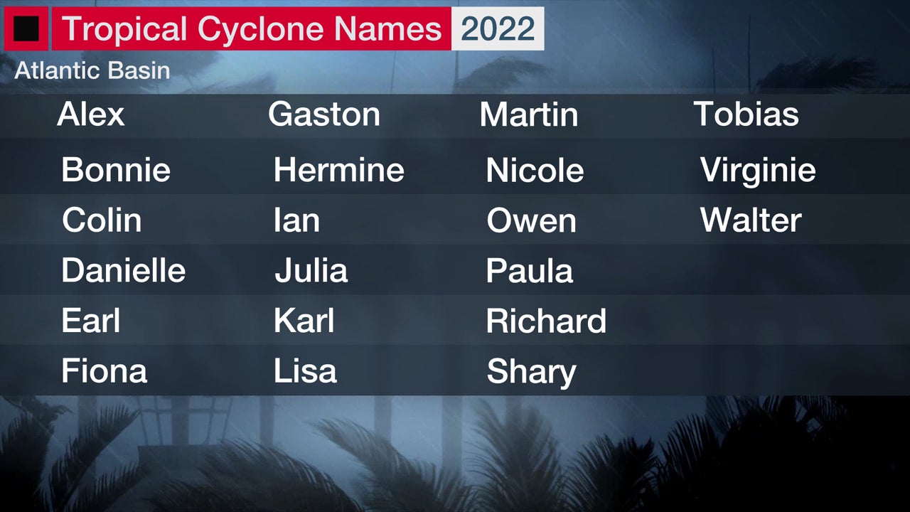
Today marks the first day of the Atlantic hurricane season, which will run until November 30. Long-term averages for the number of named storms, hurricanes, and major hurricanes are 14, 7, and 3, respectively. The list of names for 2022 is as follows:
St. Thomas St. John adjacent Islands-St Croix-
Nearshore Atlantic and adjacent Caribbean Coastal Waters-
5:28 AM AST Wed Jun 1 2022

This Hazardous Weather Outlook is for the U.S. Virgin Islands and the adjacent Coastal Waters.

.Day One...Today and Tonight

.Rip Currents...There is a moderate risk of rip currents for
all local beaches today.

.Days Two through Seven...Thursday through Tuesday

A moderate risk of rip currents is expected for most of the local
beaches during most of the period.

.Spotter information statement...

Spotter activation is not anticipated. Please relay any information
about winds, waves, and rip currents to the National Weather Service
in San Juan while following all local and state guidelines.

This report, the Tropical Weather Outlook, briefly describes significant areas of disturbed weather and their potential for  tropical cyclone formation during the next five days.

The issuance  times of this product are 2 AM, 8 AM, 2 PM, and 8 PM EDT.  After the  change to standard time in November, the issuance times are 1 AM, 7  AM, 1 PM, and 7 PM EST. A Special Tropical Weather Outlook will be issued to provide  updates, as necessary, in between the regularly scheduled issuances  of the Tropical Weather Outlook.  Special Tropical Weather Outlooks  will be issued under the same WMO and AWIPS headers as the regular

Tropical Weather Outlooks. A standard package of products, consisting of the tropical cyclone  public advisory, the forecast/advisory, the cyclone discussion, and  a wind speed probability product, is issued every six hours for all  ongoing tropical cyclones.  In addition, a special advisory package  may be issued at any time to advise of significant unexpected  changes or to modify watches or warnings.

The Tropical Cyclone Update is a brief statement to inform of  significant changes in a tropical cyclone or to post or cancel  watches or warnings.  It is used in lieu of or to precede the  issuance of a special advisory package.

Tropical Cyclone Updates,  which can be issued at any time, can be found under WMO header  WTNT61-65 KNHC, and under AWIPS header MIATCUAT1-5. All National Hurricane Center text and graphical products are available on the web at https://www.hurricanes.gov. More information  on NHC text products can be found at  https://www.hurricanes.gov/aboutnhcprod.shtml, while more  information about NHC graphical products can be found at  https://www.hurricanes.gov/aboutnhcgraphics.shtml.

You can also interact with NHC on Facebook at  https://www.facebook.com/NWSNHC. Notifications are available via  Twitter when select National Hurricane Center products are issued.   Information about our Atlantic Twitter feed (@NHC_Atlantic) is  available at https://www.hurricanes.gov/twitter.php.

CNH vigila zona cerca del Golfo de México con potencial alto de desarrollo, pero no se espera impactos en PR o USVI. #prwx #usviwx