
SAN JUAN — ![]()
![]() Expect heat indices to reach 112ºF or higher across northern, northwest Puerto Rico, Culebra, Vieques, and the U.S. Virgin Islands today.
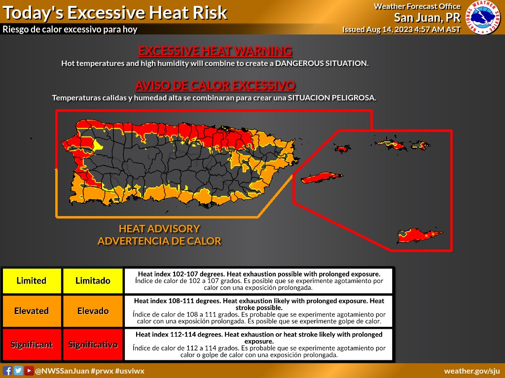
Expect heat indices to reach 112ºF or higher across northern, northwest Puerto Rico, Culebra, Vieques, and the U.S. Virgin Islands today.
While over eastern, eastern interior, southern and southwestern Puerto Rico, expect the indices to reach 108ºF or higher. Elsewhere, heat indices will reach about 102F.
.A hazy week ahead, at least through Thursday…
Based on guidance, a severe to extreme dust event is expected with Aerosol Optical Depth values between 0.40 to 0.80. The peak of the event is Tuesday-Wednesday.

• The record for August: optical depth near 0.74 back in 2018.
• The all-time record: optical depth near 1.80 back in June 2020, known as the Godzilla Event.
Eastern Tropical Atlantic
A tropical wave is forecast to move off the west coast of Africa on Wednesday or early Thursday.
Some slow development of this system will be possible late this week while the system moves gradually west-northwestward or northwestward across the eastern Atlantic.
It has a near zero chance of formation through 48 hours and a low (30 percent) chance in the next seven days.

Central Tropical Atlantic:
Another area of low pressure could develop by the middle to latter portion of this week over the east-central tropical Atlantic several hundred miles southwest of the Cabo Verde Islands.
Some slow development of this system is also possible as it moves west-northwestward over the central tropical Atlantic.
* Formation chance through 48 hours…low…near 0 percent.
* Formation chance through 7 days…low…20 percent.