
MIAMI — Forecasters at the National Hurricane Center are warning they may be making a last-minute call on a storm system quickly approaching the Virgin Islands.
“Tropical storm watches or warnings could be required with shorter-than-normal lead times for the Leeward Islands, Virgin Islands and Puerto Rico,” the NHC warned in its 8 p.m. advisory Sunday night.
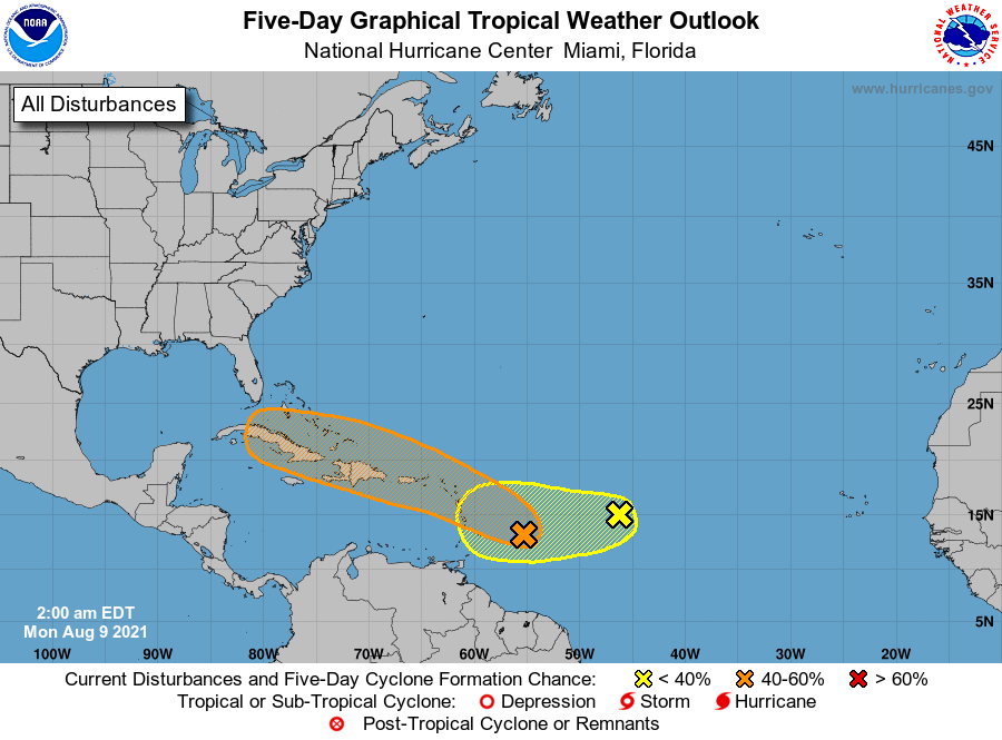
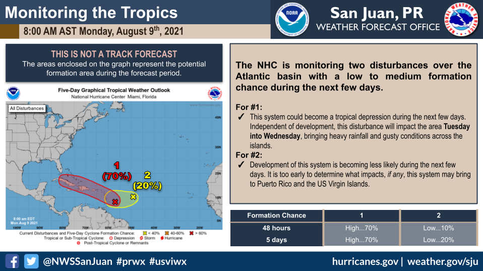
The system of immediate concern is one of two tropical waves moving in the mid- and eastern Atlantic with increased chances of developing.
A broad area of low pressure located several hundred miles east of the Windward Islands could become a tropical depression if favorable conditions contribute to the development of the low as it moves west-northwestward at 10 to 15 mph.
The disturbance, currently producing disorganized showers and thunderstorms, is expected to reach the Lesser Antilles today, move near the Virgin Islands and Puerto Rico on Tuesday and near Hispaniola around the middle of the week. Forecasters have given this system 50 percent odds of development in the next two days, and 60 percent in the next five days, with odds of it developing in the next two days climbing by 10 percent between the 2 and 8 p.m. advisories.
“Heavy rains and flooding are likely for the Leeward Islands, Virgin Islands, Puerto Rico. Interests in those areas should monitor the progress of this system,” the center warns.
SYSTEM #2
Another small low-pressure system over the tropical Atlantic, midway between the Cabo Verde Islands and the Lesser Antilles, has become more concentrated since Saturday and continues to bring showers and thunderstorms. Weather conditions are predicted in favor of this low pressure evolving into a tropical depression by the middle of next week, based on NHC reports.
NHC forecasters gave it a 40 percent chance of developing within five days and a 30 percent chance of developing within two.
The third wave in the Atlantic, spotted about a hundred miles west of the Windward Islands earlier Sunday, has dissipated.
If any system develops into a tropical storm with maximum sustained winds of 39 mph or greater, the first one to do so will be the sixth named storm of the season and don the moniker of Fred. If two develop, the second will be named Grace. Should one of them form, it would be ahead of when the NOAA typically expects the sixth named storm of the year to form, which according to records takes place on average around Sept. 8.
As the season pushes forward, the tropics will be entering a period of time known as the “peak of season,” which is between mid-August and mid-October and is typically the stretch of time meteorologists see the most hurricane activity.
Colorado State University published its first sub-season outlook Thursday, indicating its expectations for the next two weeks to have above-normal activity citing warmer-than-usual sea-surface temperatures.
Temperature ranges in the Caribbean and the west Atlantic are in the mid- to low 80s and appear to be “highly favorable” for tropical storm development, according to Spectrum News 13 Atlantic measurements.
DYNAMIC DUO
Both systems are being monitored for possible formation of a tropical cyclone, a rotating storm system that could range in strength from tropical depression to tropical storm to hurricane. It’s possible none will.
If a tropical depression forms, it would be the first tropical cyclone to form in the Atlantic in more than a month, since the July 1 appearance of the storm system that would become Hurricane Elsa.
The number of storms is likely to increase in frequency over the next few weeks as the season ramps up toward its September peak. The next two storm names are Fred and Grace.
Though water temperatures are plenty warm, which is favorable to storm development, other factors are in play.
“Pockets of dry air across the eastern and central Atlantic will continue to inhibit the development of the tropical waves crossing the basin,” AccuWeather Senior Meteorologist Dan Pydynowski said.
Conditions over the Atlantic have grown more favorable for storm formation, with a decline in the factors that can shut down storms, AccuWeather said.
There has been a decline in wind shear, the high-altitude crosswinds that can tear up storms, and a decreased concentration of the dry, dusty air that can inhibit storm growth.
The 2021 season is expected to produce an above-average number of storms, with NOAA forecasting seven to 10 hurricanes.