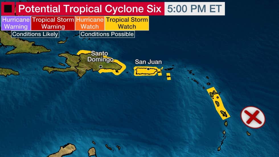
MIAMI — Tropical storm watches were issued for various Caribbean islands this evening for what soon could become the sixth named tropical storm of this year’s Atlantic hurricane season.
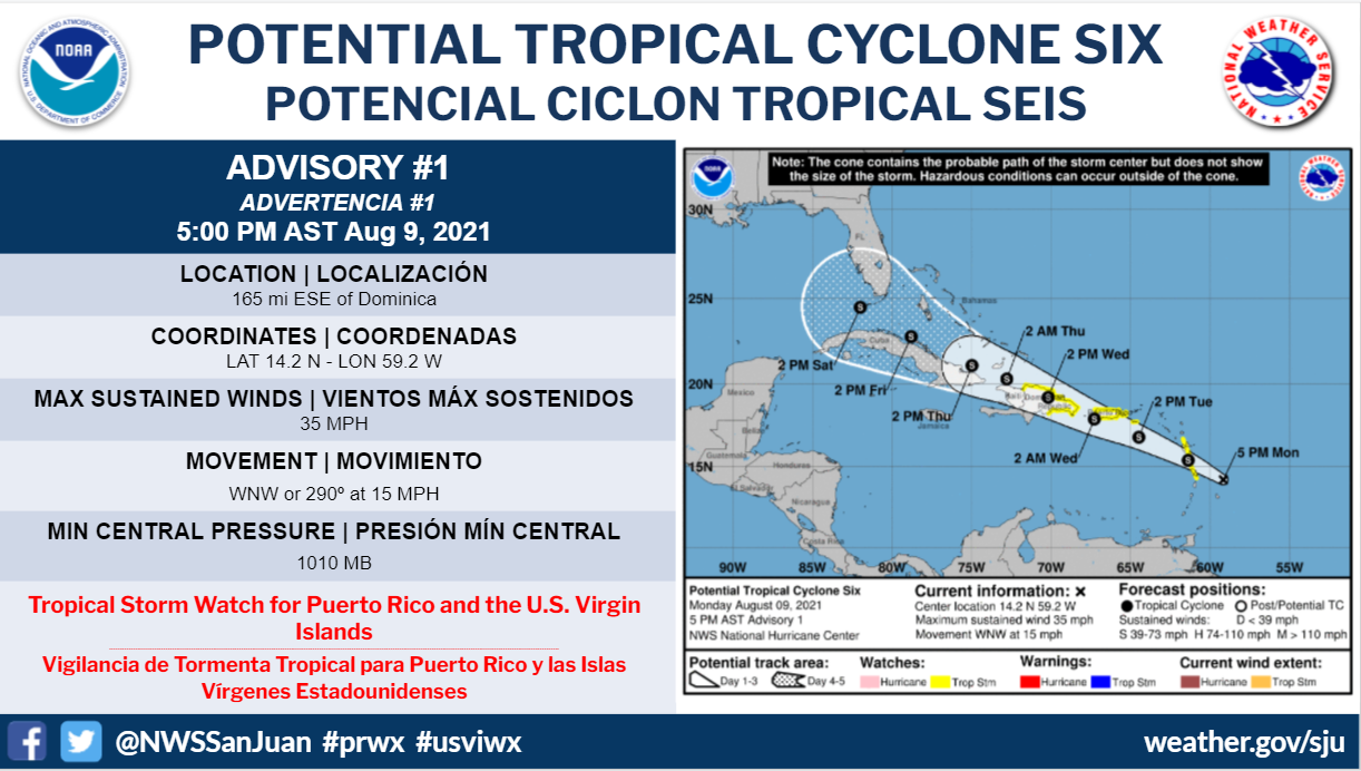
Watches were in effect for Martinique, Guadeloupe, Dominica, Puerto Rico, the U.S. Virgin Islands and the Dominican Republic, according to a 5 p.m. advisory from the National Hurricane Center. A tropical storm watch means that tropical storm conditions are possible within the watch area.
Forecasters believe the disturbance heading toward the Lesser Antilles could become Tropical Storm Fred later tonight. It has been more than a month since this year’s fifth named storm — Hurricane Elsa — formed.
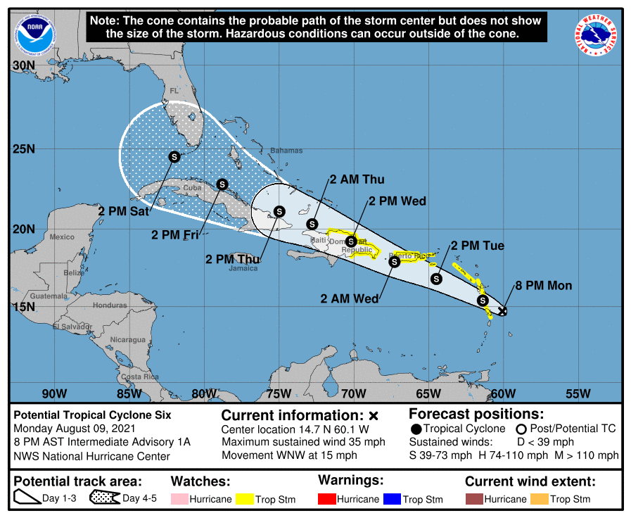
The disturbance had maximum sustained winds of 35 mph (55 kmh) with higher gusts and was 165 miles (260 kilometers) east-southeast of Dominica, according to officials. A tropical storm has maximum sustained winds of at least 39 mph (63 kmh). It was moving west-northwest at 15 mph (24 kmh).
The storm is forecast to move through a portion of the southern Leeward Islands tonight, pass near or over the U.S. Virgin Islands and Puerto Rico late Tuesday and Tuesday night, and near or over Hispaniola on Wednesday.
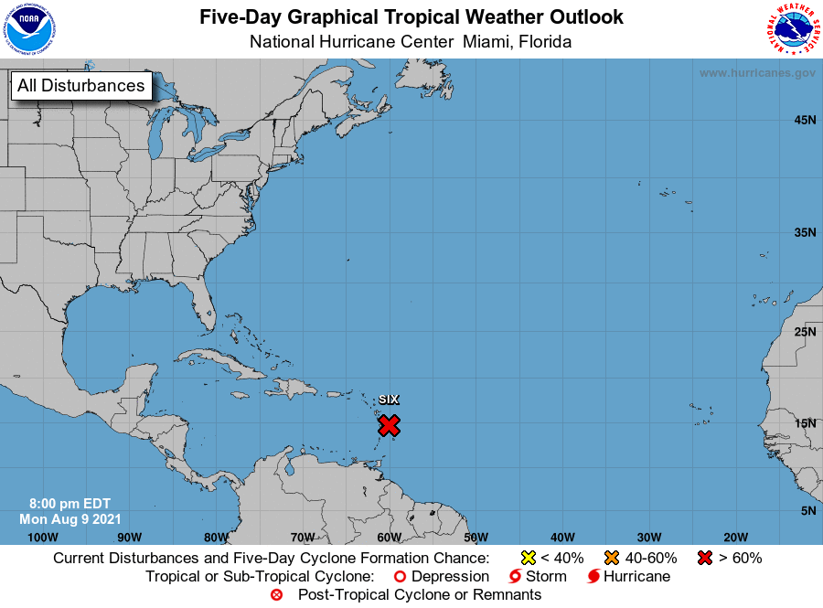
The NHC designated a low-pressure system now spreading showers and thunderstorms into the Lesser Antilles “Potential Tropical Cyclone Six” this afternoon.
It isn’t yet a depression or storm, as it has no closed low-pressure circulation at the surface. This “potential tropical cyclone” procedure allows the NHC to issue watches and warnings ahead of time for a system that hasn’t developed yet.
The NHC says this system is likely to develop by tomorrow into either a tropical depression or storm as it moves generally toward the west-northwest. The next tropical storm in the Atlantic will be named Fred.
Parts of the Lesser Antilles will likely experience gusty winds, showers and thunderstorms.
Locally heavy rain and gusty winds will then move across Puerto Rico and the U.S. Virgin Islands tomorrow and the Dominican Republic and Haiti on Wednesday.
Up to six inches of rain could fall in these areas, triggering localized flash flooding and mudslides.
AN UNCERTAIN FUTURE
Dry air, land interaction and possibly increased wind shear could all be factors that limit this system’s ability to intensify later this week as tracks in the general direction of Hispaniola, Cuba, the southern Bahamas and Florida.
More of those negative factors, such as a track over Hispaniola’s rugged mountains or more wind shear could dissipate the system. Less of those factors, such as a track avoiding much of the Caribbean islands, could result in a stronger “Fred”.
Given all the potential obstacles we described above, it’s too early to determine what, if any, other impacts there might be in Florida this weekend.
Regardless, it appears at least a surge of moisture will arrive in Florida this weekend, wringing out more frequent, concentrated areas of heavier rain than your more typical afternoon thunderstorms provide.
For now, interests from the Caribbean to the Bahamas should monitor its progress over the coming days. Now is a good time to refresh or develop your hurricane plans.
Tropical activity typically increases during August as we get closer to the peak of hurricane season so it is no surprise that there is an area to watch for tropical development.
Some 15 people on St. Michael Road in Nassau, the Bahamas said they were reading the Virgin Islands Free Press tonight for all of their updates on Tropical Storm Six, soon to be called Tropical Storm Fred. Thank you for reading! 🙂