
MIAMI — Hurricane Sam went through a weakening spell yesterday when an internal process collapsed the storm’s eyewall and a new larger one formed. Now the new one is contracting, Sam is re-strengthening and the overall system has grown in size. It’s a normal process in strong hurricanes. In fact, it was a little surprising it hadn’t happened earlier.
Now Sam is forecast to maintain Category 3 or 4 strength as it heads in the general direction of Bermuda. Most of the computer forecast models predict the storm will pass Bermuda just to the east, but it’s too early to be 100 percent sure. Since the worst weather in the hurricane is generally on the right side – the side away from the island – hopefully they’ll get by with a brush. But a good wobble to the left could make a significant difference.
Strong swells from the hurricane should subside in the northern U.S. Virgin Islands sometime today, making the surf less dangerous over time as well.

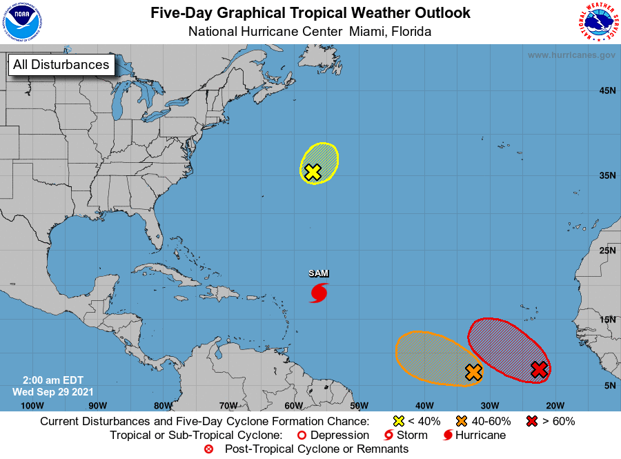
In the Atlantic between the Caribbean islands and Africa, two disturbances are getting better organized. Both have the potential to become tropical storms. If they do, the names will be Victor and Wanda.
The situation is complicated because the systems are so close together. While both systems are weak, they probably won’t influence each other very much. But if one gets significantly stronger, it will likely affect the track and strength of the other.
If they both organize and strengthen more or less in sync, Disturbance #2 would likely be deflected north, and Disturbance #1 would be held south.
There is no consistent consensus among the computer forecast models how this is going to play out, though today’s versions of the models forecast Disturbance #2 to organize first. We’ll see.

For now, none of the computer forecast models show a significant threat to land, and nothing is going to happen quickly.
So far, the Caribbean is staying quiet. We’ll see how long that lasts.
1. Shower and thunderstorm activity associated with an area of low pressure located several hundred miles south of the Cabo Verde Islands continues to gradually become better organized. Environmental conditions are conducive for additional development, and a tropical depression or tropical storm is likely to form later today or tonight while the disturbance moves west-northwestward at 10 to 15 mph over the eastern tropical Atlantic. Additional information on this system, including gale warnings, can be found in High Seas Forecasts issued by Meteo France. * Formation chance through 48 hours…high…90 percent. * Formation chance through 5 days…high…90 percent.
2. Showers and thunderstorms remain disorganized in association with a a broad and elongated area of low pressure located several hundred miles southwest of the Cabo Verde Islands. Although environmental conditions are generally conducive for development during the next day or so, interaction of this system with the low pressure area located to its east is likely to hinder development after that time. The system is forecast to drift west-northwestward over the next few days. * Formation chance through 48 hours…medium…50 percent. * Formation chance through 5 days…medium…50 percent.
3. An area of low pressure associated with the remnants of Peter is located several hundred miles east-northeast of Bermuda. Recent satellite wind data indicate that the circulation of the low has become less defined, and shower activity remains limited. The system is moving northeastward into a region of very strong upper-level winds, and significant development of this system is no longer anticipated. Additional information on this system can be found in High Seas Forecasts issued by the National Weather Service. * Formation chance through 48 hours…low…10 percent. * Formation chance through 5 days…low…10 percent.

High Seas Forecasts issued by the National Weather Service can be found under AWIPS header NFDHSFAT1, WMO header FZNT01 KWBC, and online at ocean.weather.gov/shtml/NFDHSFAT1.php
High Seas Forecasts issued by Meteo France can be found under WMO header FQNT50 LFPW and available on the web at www.meteofrance.com/previsions-meteo-marine/bulletin/grandlarge/ metarea2

