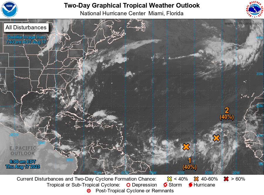
SAN JUAN — The V.I. Freep weather team is watching two areas of disturbed weather that could develop into tropical systems over the coming days.
The first is located 600 miles west-southwest of the Cabo Verde Islands and has a 40 percent chance of development over the next two days and 60 percent chance over the next seven days.
The National Hurricane Center is also monitoring the two tropical wave between Africa and the Caribbean. These waves should move across the offshore Atlantic waters.
Disorganized showers and thunderstorms continue in association with an elongated trough of low pressure centered over 900 miles west-southwest of the Cabo Verde Islands.
Environmental conditions appear conducive for gradual development of this system, and a
tropical depression could form during the next several days while it moves west-northwestward at 10 to 15 mph across the central tropical Atlantic.
* Formation chance through 48 hours…medium…40 percent.
* Formation chance through 7 days…medium…60 percent.

Eastern Tropical Atlantic
A broad area of low pressure, partially associated with a tropical wave, is producing a large area of disorganized showers and thunderstorms near and to the southwest of the Cabo Verde Islands.
Further development of this low is possible while it moves toward the west-northwest or northwest at around 10 mph across the eastern tropical Atlantic, and a tropical depression could form over
the weekend before environmental conditions become unfavorable for development early next week.
* Formation chance through 48 hours…medium…40 percent.
* Formation chance through 7 days…medium…60 percent.
Western Gulf of Mexico
A broad area of low pressure could form in the central or western Gulf of Mexico by the beginning of next week.
Some slow development of this system is possible thereafter as it moves westward and approaches the western Gulf of Mexico coastline by the middle of next week.
* Formation chance through 48 hours…low…near 0 percent.
* Formation chance through 7 days…low…30 percent.


